Mapping the value of nature for people
Partnership between researchers and policymakers ensures that ecosystem studies inform plans for Oxfordshire
University researchers are working in partnership with two local authorities on studies to help protect natural assets within a multi-billion-pound development region, thanks to funding from an Oxford Policy Engagement Network (OPEN) Fellowship.
Alison Smith, Senior Research Associate at the Environmental Change Institute, won a fellowship that enabled her to form a partnership with Oxfordshire County Council and Cherwell District Council (CDC). Together, the team is delivering critical ecosystem studies to inform plans for the county, which forms part of the Oxford to Cambridge Growth Arc. The arc is one of the UK’s biggest growth areas, and will include the delivery of hundreds of thousands of homes across five counties, as well as East-West Rail and a proposed £1.4bn expressway.
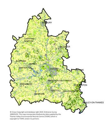
Led by Alison, the team is creating ‘Natural Capital Maps’ showing the ecosystem value of the land in Oxfordshire, including along the proposed routes for the Expressway. Unlike previous maps, which focused on high-ecological value sites such as nature reserves and Conservation Target Areas, the partnership’s work shows the ecosystem value of all the land in Oxfordshire, including farmland and domestic gardens. This land delivers a range of services that support health, wellbeing, local identity, as well as biodiversity.
The project, which included consulting with four other district councils, involved:

Map: © Crown Copyright and database right 2019. Ordnance Survey 100025252. This map incorporates biodiversity data supplied by the Thames Valley Environmental Records Centre (TVERC) which is copyright to TVERC and/or its partners.
- Creating a base map that merged detailed Ordnance Survey maps with maps of different habitats for plants and animals from the Thames Valley Environmental Record Centre
- Developing a scoring matrix to assess the value of each area of habitat for delivering 18 different ‘ecosystem services’ for people, such as flood protection, climate regulation and natural spaces for recreation This exercise built on a project for Natural England, and work previously carried out with CDC where a team developed a toolkit for sustainable development in Bicester, including at the UK’s only Eco-Town.
- Applying the scores to the base maps to show the value of the land for delivering multiple services for people.
Benefits of the research:
The new resources will give decision makers in Oxfordshire a new, co-ordinated and independently evaluated view of natural assets in areas where housing and infrastructure development is being planned, including the Expressway.
- They could help to show the value of protecting and restoring green infrastructure such as recreational spaces, woodlands, ponds, wetlands and river corridors – which support biodiversity as well as providing benefits for people
- The research will form part of the evidence base for a Joint Statutory Spatial Plan (JSSP) under development for Oxfordshire, which will set the strategic direction for planning to 2050
- The team has also agreed to make resources available for public use.
Nick Mottram, Environment Strategy Manager at Oxfordshire County Council, said:
'We are pleased to have had the opportunity to work with Alison Smith on this OPEN project. It has given us a new way to look at the environmental assets we have across the county and is re-shaping how we look at future development and the environmental impacts and opportunities this will bring. It helps to highlight that almost all undeveloped land makes some form of environmental contribution.
'Understanding what specifically this contribution is and how it varies spatially across the county is important if we are to make good, long-term, land use planning decisions. This work will shape how we and others think about and plan for natural capital into the future and has been well received by members of the Oxfordshire Growth Board. I expect it will find many other applications beyond its current focus on the Oxfordshire Plan 2050.'
With long-term relationships and partnerships with local authorities, and alignment of research and policy making, the project on the Oxford to Cambridge Growth Arc is an example of successful engagement between researchers and policy makers.
Find out more and apply for an OPEN Fellowship
Discover more stories of social sciences engagement and impact


